Indirizzo: 1200 (From 1200 To 1299) RED BANKS RD S (South), BYHALIA, MS 38611-0107, USA
Che cos'è 38611-0107? 38611-0107 è un codice di 5 Plus 4 numero di avviamento postale del 1200 (From 1200 To 1299) RED BANKS RD S (South), BYHALIA, MS, USA. Di seguito è riportato informazioni dettagliate.
38611-0107 Informazioni di base

-
CAP 5 Plus 4:
38611-0107 -
CAP 5:
38611 -
Plus 4?01074-digits that are used to identify a geographic segment within the 5-digit delivery area, such as a city block or a group of apartments or an individual high-volume receiver of mail, or any other unit that could use an extra identifier to aid in efficient mail sorting and delivery. This code is the low end of the range of +4 Codes that pertain to this ZIP Code. ZIP+4 Codes associated with nondelivery areas are composed of valid ZIP sector numbers and "ND" for the ZIP segment number, for example 12345-12ND. Non-deliverable areas are areas to which the USPS does not deliver mail, such as vacant lots and land that borders railroad tracks. Mailers should not match an address identified as a nondelivery area. If you absolutely must have numeric characters in the Plus4Code column, you may treat "ND" values as "00" (zero zero).:
-
Paese:
U.S. - Stati Uniti -
Stato:
MS - Mississippi -
Contea:
CountyFIPS: 28033 - DeSoto County -
Città:
BYHALIA -
Strada?RED BANKS RDThe official name of a street as assigned by a local governing authority. The Street Name column contains only the street name and does not include directionals (EAST, WEST, etc.) or suffixes (ST, DR, BLVD, etc.). This element may also contain literals, such as PO BOX, GENERAL DELIVERY, USS, PSC, or UNIT. Numeric street names that have numeric components that are four characters (or less) in length at are justified such that the low-order digit of the number is positioned in the fourth position of the street name column. This shift is made so that the numeric street names appear in numeric sequence.:
-
Via Suffisso?RD (Strada)The street suffix: For Example: ST = Street RD = Road DR = Drive LN = Lane:
-
Via Postdirezionale?S (South)A geographic direction that precedes the street name. For Example: 472 MAIN ST N Street Pre-Direction Abbreviation = N Spaces = No pre-direction N = North NE = Northeast E = East SE = Southeast S = South SW = Southwest W = West NW = Northwest:
-
Tipo di Record?S: StradaAn alphabetic value that identifies the type of data in the record. Record type codes include the following: G = General delivery H = Highrise F = Firm S = Street P = PO box R = Rural route/highway contract:
Indirizzo

- Numero Basso di Indirizzo Primario ?
A house, rural route, highway contract box, or post office box number; the numeric or alphanumeric component of an address preceding the street name; the low-end address in a range of addresses. Often referred to as house number.: 1200
- Numero Alto di Indirizzo Primario ?
A house, rural route, contract box, or Post Office box number. The numeric or alphanumeric component of an address preceding the street name. The high-end address in a range of addresses. Often referred to as house number.: 1299
- Indirizzo Primaria Codice Pari / Dispari ?
Code that identifies the side or sides of a street for which a given address range is applicable. For street, highrise, firm and multi-carrier records, B = Both sides of a street, E = Even side of a street (even-numbered addresses in the range); O = Odd side of a street (odd-numbered addresses in the range). For general delivery, post office box, and rural route/highway contract records, this code will always be "B" (both).: Both of Odd and Even
- Primario Gamma: 1200, 1201, 1202, 1203, 1204, 1205, 1206, 1207, 1208, 1209, 1210, 1211, 1212, 1213, 1214, 1215, 1216, 1217, 1218, 1219, 1220, 1221, 1222, 1223, 1224, 1225, 1226, 1227, 1228, 1229, 1230, 1231, 1232, 1233, 1234, 1235, 1236, 1237, 1238, 1239, 1240, 1241, 1242, 1243, 1244, 1245, 1246, 1247, 1248, 1249, 1250, 1251, 1252, 1253, 1254, 1255, 1256, 1257, 1258, 1259, 1260, 1261, 1262, 1263, 1264, 1265, 1266, 1267, 1268, 1269, 1270, 1271, 1272, 1273, 1274, 1275, 1276, 1277, 1278, 1279, 1280, 1281, 1282, 1283, 1284, 1285, 1286, 1287, 1288, 1289, 1290, 1291, 1292, 1293, 1294, 1295, 1296, 1297, 1298, 1299.
Fare clic sul "Altri esempi di indirizzi" per visualizzare l'intero elenco.
1200 RED BANKS RD S (South), BYHALIA, MS 38611-0107
1201 RED BANKS RD S (South), BYHALIA, MS 38611-0107
1202 RED BANKS RD S (South), BYHALIA, MS 38611-0107
1203 RED BANKS RD S (South), BYHALIA, MS 38611-0107
1204 RED BANKS RD S (South), BYHALIA, MS 38611-0107
1205 RED BANKS RD S (South), BYHALIA, MS 38611-0107
1206 RED BANKS RD S (South), BYHALIA, MS 38611-0107
1207 RED BANKS RD S (South), BYHALIA, MS 38611-0107
1208 RED BANKS RD S (South), BYHALIA, MS 38611-0107
1209 RED BANKS RD S (South), BYHALIA, MS 38611-0107
1210 RED BANKS RD S (South), BYHALIA, MS 38611-0107
1211 RED BANKS RD S (South), BYHALIA, MS 38611-0107
1212 RED BANKS RD S (South), BYHALIA, MS 38611-0107
1213 RED BANKS RD S (South), BYHALIA, MS 38611-0107
1214 RED BANKS RD S (South), BYHALIA, MS 38611-0107
1215 RED BANKS RD S (South), BYHALIA, MS 38611-0107
1216 RED BANKS RD S (South), BYHALIA, MS 38611-0107
1217 RED BANKS RD S (South), BYHALIA, MS 38611-0107
1218 RED BANKS RD S (South), BYHALIA, MS 38611-0107
1219 RED BANKS RD S (South), BYHALIA, MS 38611-0107
1220 RED BANKS RD S (South), BYHALIA, MS 38611-0107
1221 RED BANKS RD S (South), BYHALIA, MS 38611-0107
1222 RED BANKS RD S (South), BYHALIA, MS 38611-0107
1223 RED BANKS RD S (South), BYHALIA, MS 38611-0107
1224 RED BANKS RD S (South), BYHALIA, MS 38611-0107
1225 RED BANKS RD S (South), BYHALIA, MS 38611-0107
1226 RED BANKS RD S (South), BYHALIA, MS 38611-0107
1227 RED BANKS RD S (South), BYHALIA, MS 38611-0107
1228 RED BANKS RD S (South), BYHALIA, MS 38611-0107
1229 RED BANKS RD S (South), BYHALIA, MS 38611-0107
1230 RED BANKS RD S (South), BYHALIA, MS 38611-0107
1231 RED BANKS RD S (South), BYHALIA, MS 38611-0107
1232 RED BANKS RD S (South), BYHALIA, MS 38611-0107
1233 RED BANKS RD S (South), BYHALIA, MS 38611-0107
1234 RED BANKS RD S (South), BYHALIA, MS 38611-0107
1235 RED BANKS RD S (South), BYHALIA, MS 38611-0107
1236 RED BANKS RD S (South), BYHALIA, MS 38611-0107
1237 RED BANKS RD S (South), BYHALIA, MS 38611-0107
1238 RED BANKS RD S (South), BYHALIA, MS 38611-0107
1239 RED BANKS RD S (South), BYHALIA, MS 38611-0107
1240 RED BANKS RD S (South), BYHALIA, MS 38611-0107
1241 RED BANKS RD S (South), BYHALIA, MS 38611-0107
1242 RED BANKS RD S (South), BYHALIA, MS 38611-0107
1243 RED BANKS RD S (South), BYHALIA, MS 38611-0107
1244 RED BANKS RD S (South), BYHALIA, MS 38611-0107
1245 RED BANKS RD S (South), BYHALIA, MS 38611-0107
1246 RED BANKS RD S (South), BYHALIA, MS 38611-0107
1247 RED BANKS RD S (South), BYHALIA, MS 38611-0107
1248 RED BANKS RD S (South), BYHALIA, MS 38611-0107
1249 RED BANKS RD S (South), BYHALIA, MS 38611-0107
1250 RED BANKS RD S (South), BYHALIA, MS 38611-0107
1251 RED BANKS RD S (South), BYHALIA, MS 38611-0107
1252 RED BANKS RD S (South), BYHALIA, MS 38611-0107
1253 RED BANKS RD S (South), BYHALIA, MS 38611-0107
1254 RED BANKS RD S (South), BYHALIA, MS 38611-0107
1255 RED BANKS RD S (South), BYHALIA, MS 38611-0107
1256 RED BANKS RD S (South), BYHALIA, MS 38611-0107
1257 RED BANKS RD S (South), BYHALIA, MS 38611-0107
1258 RED BANKS RD S (South), BYHALIA, MS 38611-0107
1259 RED BANKS RD S (South), BYHALIA, MS 38611-0107
1260 RED BANKS RD S (South), BYHALIA, MS 38611-0107
1261 RED BANKS RD S (South), BYHALIA, MS 38611-0107
1262 RED BANKS RD S (South), BYHALIA, MS 38611-0107
1263 RED BANKS RD S (South), BYHALIA, MS 38611-0107
1264 RED BANKS RD S (South), BYHALIA, MS 38611-0107
1265 RED BANKS RD S (South), BYHALIA, MS 38611-0107
1266 RED BANKS RD S (South), BYHALIA, MS 38611-0107
1267 RED BANKS RD S (South), BYHALIA, MS 38611-0107
1268 RED BANKS RD S (South), BYHALIA, MS 38611-0107
1269 RED BANKS RD S (South), BYHALIA, MS 38611-0107
1270 RED BANKS RD S (South), BYHALIA, MS 38611-0107
1271 RED BANKS RD S (South), BYHALIA, MS 38611-0107
1272 RED BANKS RD S (South), BYHALIA, MS 38611-0107
1273 RED BANKS RD S (South), BYHALIA, MS 38611-0107
1274 RED BANKS RD S (South), BYHALIA, MS 38611-0107
1275 RED BANKS RD S (South), BYHALIA, MS 38611-0107
1276 RED BANKS RD S (South), BYHALIA, MS 38611-0107
1277 RED BANKS RD S (South), BYHALIA, MS 38611-0107
1278 RED BANKS RD S (South), BYHALIA, MS 38611-0107
1279 RED BANKS RD S (South), BYHALIA, MS 38611-0107
1280 RED BANKS RD S (South), BYHALIA, MS 38611-0107
1281 RED BANKS RD S (South), BYHALIA, MS 38611-0107
1282 RED BANKS RD S (South), BYHALIA, MS 38611-0107
1283 RED BANKS RD S (South), BYHALIA, MS 38611-0107
1284 RED BANKS RD S (South), BYHALIA, MS 38611-0107
1285 RED BANKS RD S (South), BYHALIA, MS 38611-0107
1286 RED BANKS RD S (South), BYHALIA, MS 38611-0107
1287 RED BANKS RD S (South), BYHALIA, MS 38611-0107
1288 RED BANKS RD S (South), BYHALIA, MS 38611-0107
1289 RED BANKS RD S (South), BYHALIA, MS 38611-0107
1290 RED BANKS RD S (South), BYHALIA, MS 38611-0107
1291 RED BANKS RD S (South), BYHALIA, MS 38611-0107
1292 RED BANKS RD S (South), BYHALIA, MS 38611-0107
1293 RED BANKS RD S (South), BYHALIA, MS 38611-0107
1294 RED BANKS RD S (South), BYHALIA, MS 38611-0107
1295 RED BANKS RD S (South), BYHALIA, MS 38611-0107
1296 RED BANKS RD S (South), BYHALIA, MS 38611-0107
1297 RED BANKS RD S (South), BYHALIA, MS 38611-0107
1298 RED BANKS RD S (South), BYHALIA, MS 38611-0107
1299 RED BANKS RD S (South), BYHALIA, MS 38611-0107
Indirizzo Esempio
BYHALIA MS 38611-0107
UNITED STATES OF AMERICA
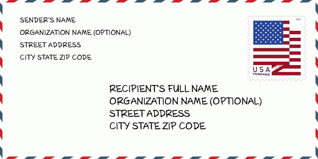
38611-0107 Esempio di busta

-
Questo è un esempio di busta statunitense. Inserisci le informazioni del mittente in alto a sinistra e le informazioni del destinatario in basso a destra. Le informazioni necessarie sono il nome completo del mittente/destinatario, l'indirizzo, la città, lo stato e il codice postale. Le informazioni sull'indirizzo del destinatario sono state fornite come riferimento. In generale, se non sei sicuro del codice postale completo di 9 cifre, puoi inserire solo il codice postale di 5 cifre per evitare la perdita del pacco.
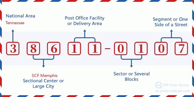
38611-0107 Significato di base
-
Cosa significa ogni cifra del CAP 38611-0107? Il CAP+4 è composto da due parti, le prime cinque cifre possono essere localizzate all'ufficio postale e le ultime quattro cifre possono identificare un segmento geografico all'interno dell'area di consegna a cinque cifre. Le 6-7 cifre indicano un settore o più blocchi e le 8-9 cifre indicano un segmento o un lato di una strada.

- ·Itinerario di spedizione ID?
A 4-digit code assigned to a mail delivery or collection route within a 5-digit ZIP Code. The first character of this identification is alphabetical, and the last three are numeric: Bnnn = PO box Hnnn = Highway contract Rnnn = Rural route Cnnn = City delivery Gnnn = General delivery: R002 (Percorso Rurale)
- ·ZIP Add-On Settore Basso?
The ZIP Add-On Low Sector and the ZIP Add-On Low Segment together form the ZIP Add-On Low Number. The ZIP Add-On Low Number is the last four positions of a ZIP+4 code; the low-end ZIP add-on in a range of codes; the add-on of the first ZIP+4 code in a consecutive series of ZIP+4 codes assigned to the delivery address. For example, most delivery addresses are assigned a single ZIP+4 code. However, large companies may be given a range of ZIP+4 codes that can be used to route mail to specific departments. A range of ZIP+4 codes can also be assigned to a corresponding range of post office boxes, and each box is mapped, one-to-one, with a ZIP+4 code in the range. A single post office box can also be assigned a range of ZIP+4 codes.: 01
- ·ZIP Add-On Segmento Basso ?
The ZIP Add-On Low Sector and the ZIP Add-On Low Segment together form the ZIP Add-On Low Number. The ZIP Add-On Low Number is the last four positions of a ZIP+4 code; the low-end ZIP add-on in a range of codes; the add-on of the first ZIP+4 code in a consecutive series of ZIP+4 codes assigned to the delivery address. For example, most delivery addresses are assigned a single ZIP+4 code. However, large companies may be given a range of ZIP+4 codes that can be used to route mail to specific departments. A range of ZIP+4 codes can also be assigned to a corresponding range of post office boxes, and each box is mapped, one-to-one, with a ZIP+4 code in the range. A single post office box can also be assigned a range of ZIP+4 codes.: 07
- ·ZIP Add-On Settore Alto?
The ZIP Add-On High Sector and the ZIP Add-On High Segment together form the ZIP Add-On High Number, which is the high-end ZIP add-on in a range of codes; the add-on of the last ZIP+4 code in a consecutive series of ZIP+4 codes assigned to the delivery address. Most delivery addresses are assigned a single ZIP+4 code; however, large companies may be given a range of ZIP+4 codes that can be used to route mail to specific departments. A range of ZIP+4 codes can also be assigned to a corresponding range of post office boxes, and each box is mapped, one-to-one, with a ZIP+4 code in the range. A single post office box can also be assigned a range of ZIP+4 codes. (See also ZIP Add-On Code.): 01
- ·ZIP Add-On Segmento Alto?
The ZIP Add-On High Sector and the ZIP Add-On High Segment together form the ZIP Add-On High Number, which is the high-end ZIP add-on in a range of codes; the add-on of the last ZIP+4 code in a consecutive series of ZIP+4 codes assigned to the delivery address. Most delivery addresses are assigned a single ZIP+4 code; however, large companies may be given a range of ZIP+4 codes that can be used to route mail to specific departments. A range of ZIP+4 codes can also be assigned to a corresponding range of post office boxes, and each box is mapped, one-to-one, with a ZIP+4 code in the range. A single post office box can also be assigned a range of ZIP+4 codes. (See also ZIP Add-On Code.): 07
- ·Codice Postale Aggiungi su: 0107
- ·Gamma?
The range of +4 codes. Summing the +4 Code and the +4 Range will give you the high end of the range of +4 Codes that pertain to this ZIP Code.: 0
- ·Codice Alternativo di base?
Code that specifies whether a record is a base (preferred) or alternate record. Base records (represented as "B") can represent a range of addresses or an individual address, such as a firm record, while alternate records (represented as "A") are individual delivery points. Government deliveries will only be listed on alternate records with the appropriate government building indicator (federal, state, or city) set.: Base
- ·Numero finanziario?
A code assigned to Postal Service facilities (primarily post offices) to collect cost and statistical data and compile revenue and expense data. The state number comprises the first two positions of the finance number.: 271092
- ·Numero di distretto del Congresso?
A standard value identifying a geographic area within the United States served by a member of the US House of Representatives or Senate. If Army/Air Force (APO) or fleet post office (FPO), this column will be blank. If there is only one member of Congress within a state, the code will be "AL" (at large).: 01
- ·Preferito Ultima Linea per Chiave Statale ?
An index to the City State file that provides the preferred last-line name for this address range.: Y13338
Online Mappa

Questa è la online mappa dell'indirizzo 1200 RED BANKS RD, BYHALIA. Possibile usare bottone a muovere e sfrecciare in/fuori. Le informazioni di mappa è solo per riferimento.
Indirizzo: 1200 (From 1200 To 1299) RED BANKS RD S (South), BYHALIA, MS 38611-0107, USA
Commento


