アドレス: 200 (From 200 To 298) ROAD 806, TUPELO, MS 38804-04ND, USA
38804-04NDとは? 38804-04ND 200 (From 200 To 298) ROAD 806, TUPELO, MS, USA の5桁郵便番号に4桁をプラスした番号である。以下は詳細情報である。
38804-04ND基本情報

ストリートプレ方向指示器?
A geographic direction that precedes the street name.
| ストリート?
The official name of a street as assigned by a local governing authority. The Street Name column contains only the street name and does not include directionals (EAST, WEST, etc.) or suffixes (ST, DR, BLVD, etc.). This element may also contain literals, such as PO BOX, GENERAL DELIVERY, USS, PSC, or UNIT. Numeric street names that have numeric components that are four characters (or less) in length at are justified such that the low-order digit of the number is positioned in the fourth position of the street name column. This shift is made so that the numeric street names appear in numeric sequence.
| ストリートサフィックス?
The street suffix:
For Example:
ST = Street
RD = Road
DR = Drive
LN = Lane
| 市 | レコード形式?
An alphabetic value that identifies the type of data in the record. Record type codes include the following:
G = General delivery
H = Highrise
F = Firm
S = Street
P = PO box
R = Rural route/highway contract
| 状態 |
|---|---|---|---|---|---|
| COUNTY LINE | RD | TUPELO | S | 有効 | |
| ROAD 1015 | TUPELO | S | 有効 | ||
| ROAD 806 | TUPELO | S | 有効 |
アドレス

38804-04ND は以下のアドレスに対応します。
| アドレス一覧 | 状態 |
|---|---|
| 1 (From 1 To 99) COUNTY LINE RD SW (Southwest), TUPELO, MS 38804-04ND, USA | 有効 |
| 2 (From 2 To 98) COUNTY LINE RD SW (Southwest), TUPELO, MS 38804-04ND, USA | 有効 |
| 701 (From 701 To 799) COUNTY LINE RD SW (Southwest), TUPELO, MS 38804-04ND, USA | 有効 |
| 901 (From 901 To 999) COUNTY LINE RD, TUPELO, MS 38804-04ND, USA | 有効 |
| 901 (From 901 To 999) COUNTY LINE RD SW (Southwest), TUPELO, MS 38804-04ND, USA | 有効 |
| 201 (From 201 To 229) ROAD 1015, TUPELO, MS 38804-04ND, USA | 有効 |
| 200 (From 200 To 298) ROAD 806, TUPELO, MS 38804-04ND, USA | 有効 |
リスト全体を表示するには、"その他の住所の例"をクリックしてください。
アドレス例
アドレスは次の行で構成されています。
200
ROAD 806
TUPELO MS 38804-04ND
UNITED STATES OF AMERICA
または詳細については、以下の封筒の例をご覧ください。
TUPELO MS 38804-04ND
UNITED STATES OF AMERICA
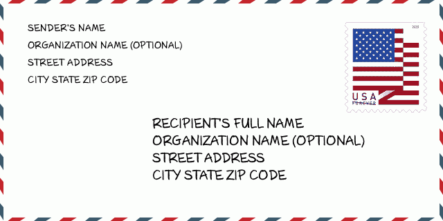
38804-04ND封筒の例

-
これは米国の封筒の例です。左上に送信者の情報を入力し、右下に受信者の情報を入力します。必要な情報は、送信者/受信者の氏名、住所、都市、州、および郵便番号です。参照用に受信者のアドレス情報が提供されています。通常、完全な9桁の郵便番号がわからない場合は、パッケージの紛失を防ぐために5桁の郵便番号のみを入力できます。
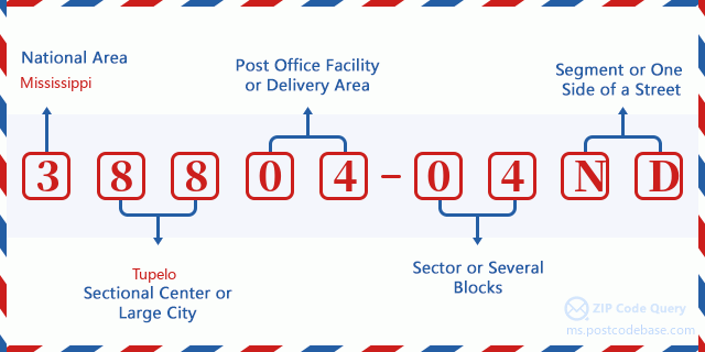
38804-04ND基本的な意味
-
郵便番号38804-04NDの各桁は何を表していますか?ZIP + 4コードは2つの部分で構成され、最初の5桁は郵便局に配置でき、最後の4桁は5桁の配達エリア内の地理的セグメントを識別できます。 6〜7桁はセクターまたは複数のブロックを示し、8〜9桁はセグメントまたは通りの片側を示します。

オンライン地図

これは住所200 ROAD 806 TUPELOに対応するオンライン地図である。地図の中のボタンを利用して移動、拡大・縮小を実現できる。地図情報はただご参考にされて下さい。
アドレス: 200 (From 200 To 298) ROAD 806, TUPELO, MS 38804-04ND, USA
コメント


コメントを追加